On the Real Watership Down
Cowslip’s Warren
This page has been superseded. Click here for the latest version.
The corner of the opposite wood turned out to be an acute point. Beyond it, the ditch and trees curved back again in a re-entrant, so that the field formed a bay with a bank running all the way round. It was evident now why Cowslip, when he left them, had gone among the trees. He had simply run in a direct line from their holes to his own, passing on his way through the narrow strip of woodland that lay between.
Indeed, as Hazel turned the point and stopped to look about him, he could see the place where Cowslip must have come out. A clear rabbit-track led from the bracken, under the fence and into the field. In the bank on the further side of the bay the rabbit-holes were plain to see, showing dark and distinct in the bare ground. It was as conspicuous a warren as could well be imagined.
Chapter Thirteen—Hospitality.
In Chapter Twelve, The Stranger In The Field, the Sandleford rabbits leave the heather and unwelcoming woodland of Newtown Common behind them, breaking into beautiful open meadows and long grass. Keen to remain in such a beautiful location, the rabbits begin to scrape shallow holes close to an oak tree between two copses. With rain imminent, the light-hearted digging is interrupted by a large, well kept rabbit sat in front of the opposite area of woodland. He introduces himself as Cowslip, and invites the hlessil to stay in his warren’s numerous ’empty burrows’. The travellers are non-committal and Cowslip heads back to his warren, the offer still open.
As the rain begins to pour, the rabbits are beautifully described by Richard Adams as ‘a muddy handful of scratchers, crouching in a narrow, draughty pit in lonely country. They were not out of the weather. They were waiting, uncomfortably, for the weather to change.’ They need no persuasion to accept Cowslip’s proposal. Only Fiver protests, as if he senses something is badly wrong, not that he is entirely certain of the source of his fears.
The subsequent five chapters reveal the chillingly eerie denialism of the warren’s inhabitants in the face of an unspoken secret they all share and accept. It is only when Bigwig is almost killed in a snare (Chapter Seventeen, The Shining Wire) that things become clearer and the Sandleford rabbits flee.
The film’s coverage of this sequence is condensed, but the essential truths remain. And who can forget the infamous scene in which Bigwig chokes blood in the snare as flies swarm around his suffocating body?

Bigwig wishes he had listened to Fiver’s protests … each and every one.
It’s a tough scene to watch, and almost as difficult as trying to uncover the real location in which the Warren of the Snares, or Cowslip’s Warren—call it what you will—was situated. We know that the rabbits’ travels took them roughly south-south-west from Newtown Church and through the dense, alien undergrowth of Newtown Common. The open meadowland which they subsequently find themselves in is to the east of the pretty village of Burghclere and south of the hamlet of Adbury and its country estate.
It’s here that things get really confusing. Adams makes reference to the rabbits frolicking alongside a brook. Using Google Maps, I found that the first brook the rabbits would have encountered after entering the fields lay to the west of High Wood, an identical name to one of the copses at Sandleford Warren. To locate the site of Cowslip’s warren, I used this extract from Chapter Thirteen, Hospitality:
‘The corner of the opposite wood turned out to be an acute point. Beyond it, the ditch and trees curved back again in a re-entrant, so that the field formed a bay with a bank running all the way round.’
Studying the map, High Wood seems to possess the most obvious bay in any Hampshire field. This accepted, it made sense that the Sandleford rabbits’ scratchings were off to the south west, on the north eastern edge of Dovey’s Copse.

The 1942 Ordnance Survey map showing the brook and bay between high wood and Frith Copse.
Then I decided to cross-reference my conclusion with the other Watership Down sites online. David Buttery seemed to share pretty much the same solution as me as to High Wood being the site of Cowslip’s home, but Chris Boyce offered a different view. He gives Frith Copse (another appropriately Watership Down name) as the location of the warren. Even so, I rejected his view whilst looking at Google Maps as there just doesn’t seem to be a suitable bay around the wood’s edges.
In April 2025, following a rather unsuccessful visit to drone the site—I chose a bad location to launch from and upset a farmer who was extremely suspicious of my motives—I re-read the chapters related to Cowslip’s Warren.
Chapter Twelve makes reference to Cowslip’s initial meeting with the Sandleford rabbits. At its conclusion, Cowslip ‘ran down the slope and over the brook.’ If this was the case then I must be wrong: no brook runs between Dovey Copse and High Wood.
I turned to some old online maps to do some further research and was shocked by the changes in the topography through the years. Staring up at me from the 1888 and 1942 maps was a brook (or maybe a drainage ditch, who knows?) that ran midway between High Wood and Frith Copse. Also, a bay was visible where these two areas of woodland met on the perimeter of Adbury Park. By 1971 the brook had been diverted along the eastern edge of High Wood, freeing up the field for modern agricultural use. As the novel was not published until 1972, and we will probably never know how recently Adams had visited this area prior to writing about Cowslip’s warren, it is reasonable to suspect he was writing about the landscape before the brook was diverted.
The only photo I was able to take on my first visit. High Wood is the closest wood with Frith Copse behind.
The matter of the warren site resolved, I was keen to establish where the Sandleford rabbits had made their scratchings. In Chapter Twelve, Hazel states:
‘Let’s go back a little way, between the woods, and have a scratch near that oak tree there – just by that white patch of stitchwort. I know the farm’s a long way off, but there’s no point in being nearer to it than we need. And if we’re fairly close to the wood opposite, the trees will help to break the wind a bit in winter.’
Cowslip is unimpressed with Hazel’s choice of location, observing ‘We usually have a west wind and it’ll go straight into these holes.’
If the site of the scratchings is exposed to a wind coming from the west, this suggests Hazel had chosen a site somewhere just beyond High Wood’s southern tip. Perhaps it is noteworthy that the 1888-1915 Ordnance Survey map shows a solitary tree on a very likely spot. Whether this was the oak tree in question I don’t know—the 1942 map betrays Ordnance Survey’s shift away from detailing notable individual trees dotting the landscape—but it’s a fair guess. As of 2025, this location is part of a scattered treeline on a field boundary.

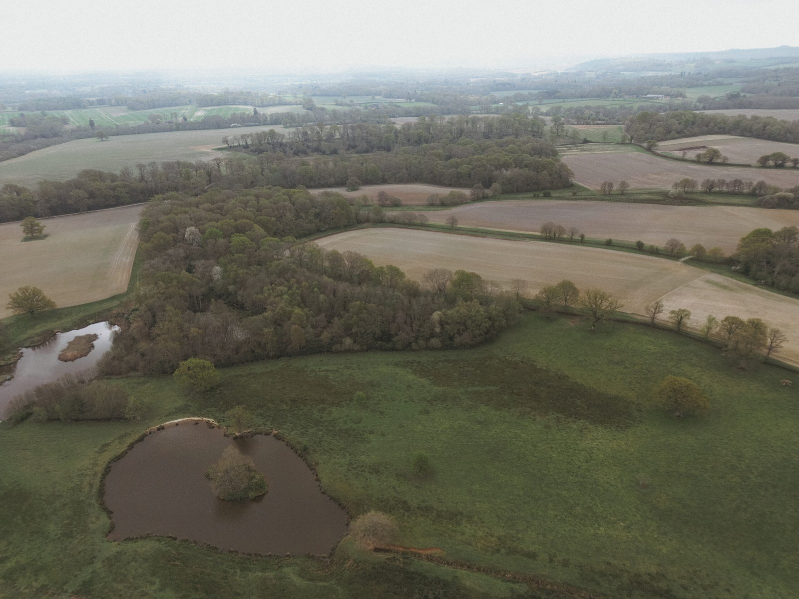
The site of Cowslip’s warren in July 2025, positioned on the treeline to the right, where the two narrow fields join.
In July 2025 I returned to the area. This time I was more succesful. The above image shows the site of the warren, positioned on the treeline to the right where the two narrow fields join end to end. The uppermost of this pair shows on old mapping as having been woodland. The Sandleford rabbits’ scratchings are likely to be somewhere along the thin treeline in the central foreground of the image.
For my second visit, I launched my drone well away from Adbury and its suspicious farmer. I followed the public footpath from Clere School (in Burghclere) that runs east through the courtyard of Palmer’s Hill House and on below Frith Copse. Here, I caught sight of the beech hanger atop Watership Down. For a fleeting moment, with my camera just a few inches above the path, I imagined the Sandleford rabbits and Strawberry dashing from Cowslip’s Warren, over the ‘cart track’ where I crouched, through Badmore Copse, heading south to the high ground—just as they did at the end of Chapter Seventeen.
Gallery

Rabbit’s eye view south from the ‘cart track’. Just right of centre, the gap in the trees is filled by the distant escarpment of Watership Down.

An 1888-1915 ordnance survey map, closely reflecting that of 1942.
