On the Real Watership Down
The Plank Bridge
Hazel and the Watership Down rabbits wait for Bigwig to emerge from his mission inside Efrafa.
They soon realized that the woodland on this left bank was lonely, thick and overgrown—denser than the nut copses and bluebell woods of Sandleford. Several times they heard the drumming of a great woodpecker, the shyest of birds. As Blackberry was suggesting that perhaps they might look for a hiding-place somewhere in this jungle, they became aware of another sound—the falling water which they had heard on their approach the day before. Soon they reached a place where the river curved round in a bend from the east, and here they came upon the broad, shallow fall. It was no more than a foot high—one of those artificial falls, common on the chalk streams, made to attract trout. Several were already rising to the evening hatch of fly.
Just above the fall a plank footbridge crossed the river. Kehaar flew up, circled the pool and perched on the hand-rail.
‘This is more sheltered and lonely than the bridge we crossed last night,’ said Blackberry. ‘Perhaps we could make some use of it. You didn’t know about this bridge, Kehaar, did you?’
‘Na, not know, not see heem. But ees goot pridge – no von come.’
Chapter Thirty Three—The Great River

The punt set against the water-meadow in the film.
In Chapter Thirty Three, The Great River, the Watership Down rabbits head south in anticipation of Bigwig freeing the Efrafan does. They enter the eastern fringes of the Laverstoke Park estate:
‘They soon realized that the woodland on this left bank was lonely, thick and overgrown—denser than the nut copses and bluebell woods of Sandleford. Several times they heard the drumming of a great woodpecker, the shyest of birds. As Blackberry was suggesting that perhaps they might look for a hiding-place somewhere in this jungle, they became aware of another sound—the falling water which they had heard on their approach the day before. Soon they reached a place where the river curved round in a bend from the east, and here they came upon the broad, shallow fall. It was no more than a foot high—one of those artificial falls, common on the chalk streams, made to attract trout. Several were already rising to the evening hatch of fly. Just above the fall a plank footbridge crossed the river.’
The bridge is set in a water-meadow (an irrigated area of land close to a stream or small river), just to the east of the shallow fall on the River Test. On the other side of the fall was a small wooden punt used for reed-cutting. It was this boat that allowed the escaping rabbits to float downstream towards the bridges. (Chapter Thirty Eight, The Thunder Breaks and Chapter Thirty Nine, The Bridges).
In the film, neither the bridge or the fall are featured. Given its importance to the story, the punt remains, albeit on a much wider River Test.
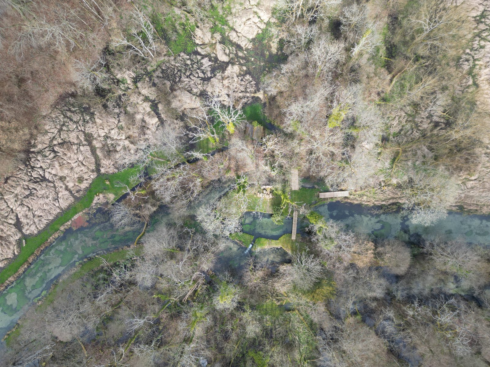
Three plank bridges. What? The one we are interested in is the lowest of the group.
I was keen to see the plank bridge, or at least its modern equivalent, though there simply is no way for anyone to access the site. Instead, I had to resort to using my drone. Finding a suitable site to take-off was far from simple, with the tree-lined roads and lanes rendering it impossible to get the drone up. I had to settle for launching from just behind the railway line south of Efrafa. Fortunately, my drone had just enough range to fly above the River Test at the correct location.
What I discovered from the air was a confusing picture, at odds with the tidy scene presented in the book. In fact, I believe this to be the part of the book where Adams took the greatest liberties in presenting the landscape. The map in Chapter Thirty Eight is as idealised as Adams’s description, both presenting the Test as a smooth, parallel sided river, when it really isn’t the case here.
In fact, there are three plank bridges, as you can see in the photo above. Old maps and today’s Ordnance Survey online map show there to be only two of them; the one that is missing is that on the right. This is at the eastern end of the finger of land that the escaping rabbits will have run onto to escape the pursuing Efrafans. Either this eastern end regularly floods or the river has eaten away here to necessitate an extra bridge.
Of the remaining pair of plank bridges, it is only the southern one that crosses the main body of the Test. Its more northerly neighbour, at least according to an early 20th century Ordnance Survey map, crosses what seems to have once been an irrigation channel.
Sadly, it is impossible to see the shallow weir in my photograph as the spot is obscured by the branches of a tree.